 |
| Seattle and/or Portland in the near future? |
New Yorker
"In the late nineteen-eighties, Brian Atwater, a geologist with the United States Geological Survey, and a graduate student named David Yamaguchi found the answer, and another major clue in the Cascadia puzzle. Their discovery is best illustrated in a place called the ghost forest, a grove of western red cedars on the banks of the Copalis River, near the Washington coast. When I paddled out to it last summer, with Atwater and Yamaguchi, it was easy to see how it got its name. The cedars are spread out across a low salt marsh on a wide northern bend in the river, long dead but still standing. Leafless, branchless, barkless, they are reduced to their trunks and worn to a smooth silver-gray, as if they had always carried their own tombstones inside them.
What killed the trees in the ghost forest was saltwater. It had long been assumed that they died slowly, as the sea level around them gradually rose and submerged their roots. But, by 1987, Atwater, who had found in soil layers evidence of sudden land subsidence along the Washington coast, suspected that that was backward—that the trees had died quickly when the ground beneath them plummeted. To find out, he teamed up with Yamaguchi, a specialist in dendrochronology, the study of growth-ring patterns in trees. Yamaguchi took samples of the cedars and found that they had died simultaneously: in tree after tree, the final rings dated to the summer of 1699. Since trees do not grow in the winter, he and Atwater concluded that sometime between August of 1699 and May of 1700 an earthquake had caused the land to drop and killed the cedars. That time frame predated by more than a hundred years the written history of the Pacific Northwest—and so, by rights, the detective story should have ended there.
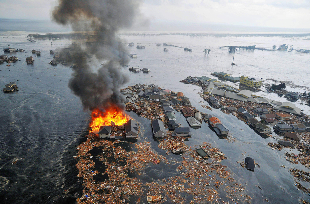
But it did not. If you travel five thousand miles due west from the ghost forest, you reach the northeast coast of Japan. As the events of 2011 made clear, that coast is vulnerable to tsunamis, and the Japanese have kept track of them since at least 599 A.D. In that fourteen-hundred-year history, one incident has long stood out for its strangeness. On the eighth day of the twelfth month of the twelfth year of the Genroku era, a six-hundred-mile-long wave struck the coast, levelling homes, breaching a castle moat, and causing an accident at sea. The Japanese understood that tsunamis were the result of earthquakes, yet no one felt the ground shake before the Genroku event. The wave had no discernible origin. When scientists began studying it, they called it an orphan tsunami.
Finally, in a 1996 article in Nature, a seismologist named Kenji Satake and three colleagues, drawing on the work of Atwater and Yamaguchi, matched that orphan to its parent—and thereby filled in the blanks in the Cascadia story with uncanny specificity. At approximately nine o’ clock at night on January 26, 1700, a magnitude-9.0 earthquake struck the Pacific Northwest, causing sudden land subsidence, drowning coastal forests, and, out in the ocean, lifting up a wave half the length of a continent. It took roughly fifteen minutes for the Eastern half of that wave to strike the Northwest coast. It took ten hours for the other half to cross the ocean. It reached Japan on January 27, 1700: by the local calendar, the eighth day of the twelfth month of the twelfth year of Genroku.
Once scientists had reconstructed the 1700 earthquake, certain previously overlooked accounts also came to seem like clues. In 1964, Chief Louis Nookmis, of the Huu-ay-aht First Nation, in British Columbia, told a story, passed down through seven generations, about the eradication of Vancouver Island’s Pachena Bay people. “I think it was at nighttime that the land shook,” Nookmis recalled. According to another tribal history, “They sank at once, were all drowned; not one survived.” A hundred years earlier, Billy Balch, a leader of the Makah tribe, recounted a similar story. Before his own time, he said, all the water had receded from Washington State’s Neah Bay, then suddenly poured back in, inundating the entire region. Those who survived later found canoes hanging from the trees. In a 2005 study, Ruth Ludwin, then a seismologist at the University of Washington, together with nine colleagues, collected and analyzed Native American reports of earthquakes and saltwater floods. Some of those reports contained enough information to estimate a date range for the events they described. On average, the midpoint of that range was 1701.
It does not speak well of European-Americans that such stories counted as evidence for a proposition only after that proposition had been proved. Still, the reconstruction of the Cascadia earthquake of 1700 is one of those rare natural puzzles whose pieces fit together as tectonic plates do not: perfectly. It is wonderful science. It was wonderful for science. And it was terrible news for the millions of inhabitants of the Pacific Northwest. As Goldfinger put it, “In the late eighties and early nineties, the paradigm shifted to ‘uh-oh.’ ”
Goldfinger told me this in his lab at Oregon State, a low prefab building that a passing English major might reasonably mistake for the maintenance department. Inside the lab is a walk-in freezer. Inside the freezer are floor-to-ceiling racks filled with cryptically labelled tubes, four inches in diameter and five feet long. Each tube contains a core sample of the seafloor. Each sample contains the history, written in seafloorese, of the past ten thousand years. During subduction-zone earthquakes, torrents of land rush off the continental slope, leaving a permanent deposit on the bottom of the ocean. By counting the number and the size of deposits in each sample, then comparing their extent and consistency along the length of the Cascadia subduction zone, Goldfinger and his colleagues were able to determine how much of the zone has ruptured, how often, and how drastically.
Thanks to that work, we now know that the Pacific Northwest has experienced forty-one subduction-zone earthquakes in the past ten thousand years. If you divide ten thousand by forty-one, you get two hundred and forty-three, which is Cascadia’s recurrence interval: the average amount of time that elapses between earthquakes. That timespan is dangerous both because it is too long—long enough for us to unwittingly build an entire civilization on top of our continent’s worst fault line—and because it is not long enough. Counting from the earthquake of 1700, we are now three hundred and fifteen years into a two-hundred-and-forty-three-year cycle."
No comments:
Post a Comment
Note: Only a member of this blog may post a comment.